How Aerial Photography Helps Verify Work Quality in Construction
As construction projects move deeper into execution, the focus begins to shift. Early stages are about planning and setup. Mid-project, the question becomes more direct.
Is the work being done correctly?
For homeowners, contractors, project managers, and insurance professionals, this question is not about appearance. It is about accuracy, compliance, and long-term performance. Mistakes at this stage are costly. Miscommunication creates delays. Assumptions create risk.
This is where drone photography for construction becomes essential.
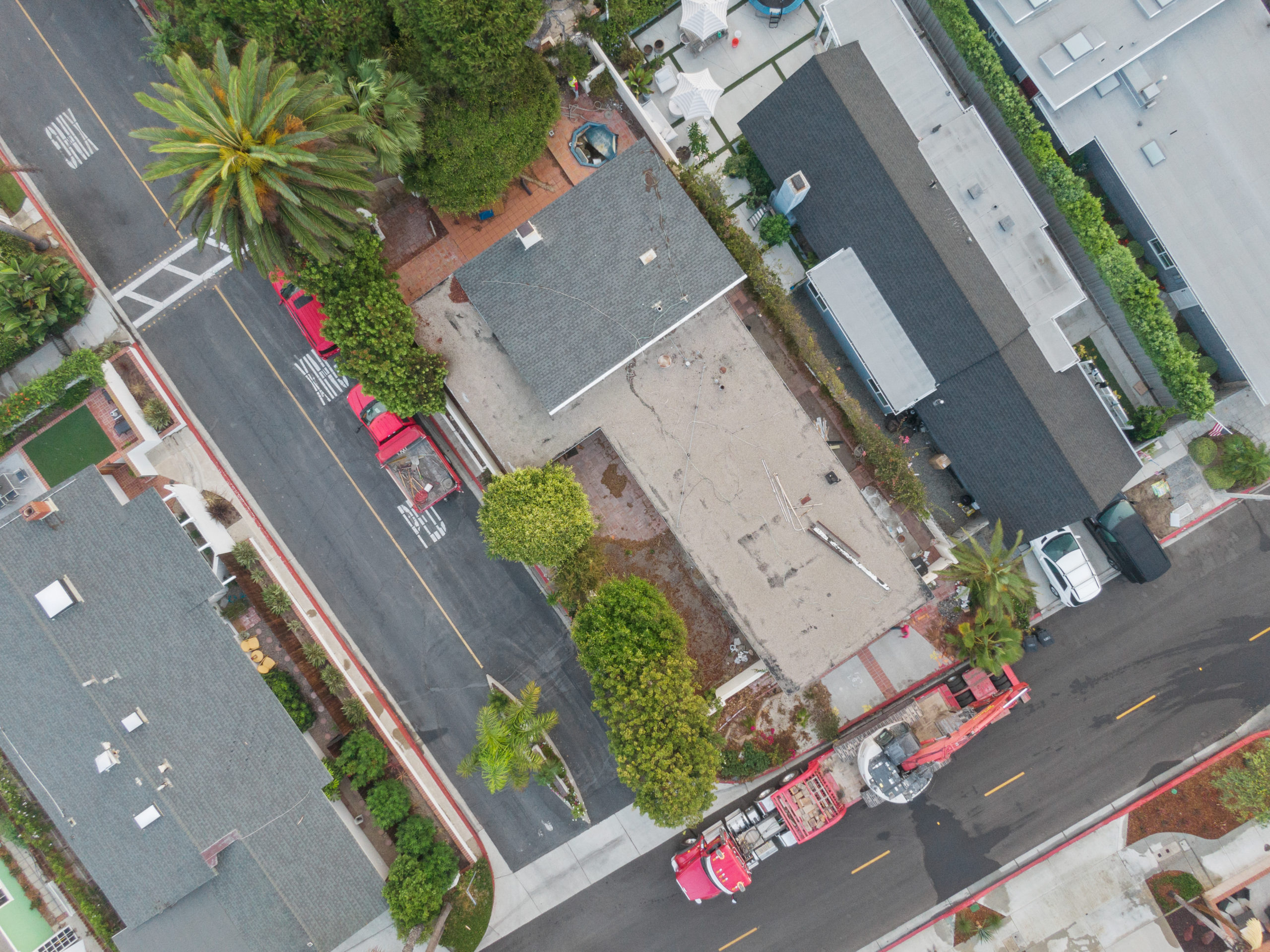
Aerial photography provides a clear, objective view of the work being performed. It allows stakeholders to verify quality, identify issues early, and maintain accountability across every phase of a project.
Why Verifying Construction Quality Is Challenging
Construction sites are complex environments. Multiple teams work simultaneously. Tasks are completed in layers. Some of the most critical work is not easily visible once it is finished.
From the ground, it is difficult to evaluate:
- Roof installation accuracy
- Structural alignment across large areas
- Site grading and drainage patterns
- Material consistency across elevations
- Work completed in hard-to-reach areas
Even regular site visits can miss details. Angles are limited. Access is restricted. Timing does not always align with key stages of work.
Without proper documentation, verification becomes subjective.
How Drone Photography Improves Construction Quality Verification
Drone photography introduces a new level of visibility. It allows stakeholders to step back and evaluate the project as a whole while still capturing detailed visuals where needed.
Full-Site Visibility
Aerial photography provides a complete view of the site in a single frame. This makes it easier to identify inconsistencies, gaps, or areas that require closer inspection.
Repeatable Documentation
Consistent aerial capture allows teams to compare different stages of the project. This helps verify whether work has been completed correctly over time.
Safe Access to Critical Areas
Roofs, elevated structures, and large commercial properties can be difficult and unsafe to inspect manually. Drone photography provides access without disrupting the project.
Objective Visual Evidence
Images captured from consistent angles serve as documentation. They remove ambiguity and support clear decision-making.
Aerial Inspection Services in Practice
Aerial inspection services are not limited to capturing images. They support real-world verification processes across different types of projects.
Roofing and Structural Work
Drone photography allows teams to inspect:
- Shingle or membrane installation
- Flashing and edge details
- Structural framing alignment
- Areas that are not visible from the ground
Commercial and Multi-Unit Projects
Large-scale sites benefit from aerial inspection because:
- Multiple work zones can be reviewed at once
- Progress can be verified across buildings
- Site organization and safety can be evaluated
Maintenance and Repair Projects
For maintenance work, aerial documentation helps confirm:
- The extent of repairs completed
- Condition improvements over time
- Areas that may require additional attention
These insights support better planning and reduce the likelihood of missed issues.
Supporting Contractor Accountability
Accountability is one of the most important aspects of any construction project.
Clear documentation ensures that:
- Work aligns with the agreed scope
- Milestones are completed as expected
- Quality standards are maintained
- Communication remains consistent
Drone photography provides a shared visual reference. Instead of relying on descriptions, all parties can review the same images.
This reduces misunderstandings and builds trust between contractors, clients, and project managers.
The Role of Aerial Photography in Reporting
Accurate reporting is critical, especially for stakeholders who are not onsite regularly.
Aerial documentation supports reporting by:
- Providing visual summaries of progress
- Highlighting completed and pending work
- Supporting investor and client updates
- Creating records for insurance and compliance
When paired with structured reporting, drone photography transforms updates from general descriptions into clear, visual narratives.
Early Issue Detection and Cost Prevention
One of the most valuable benefits of aerial photography is early detection.
Small issues can become major problems if they are not identified quickly. Misaligned materials, incomplete sections, or installation errors may not be visible from the ground.
Aerial views allow teams to:
- Spot inconsistencies early
- Address problems before they escalate
- Avoid costly rework
- Maintain project timelines
Preventing a single major issue can offset the cost of documentation many times over.
Who Benefits Most from Construction Quality Verification
Homeowners
They gain confidence that their project is being completed correctly, especially during renovations where visibility is limited.
Property Managers
They receive accurate records for maintenance and tenant communication.
Developers and Investors
They can verify progress and quality without relying solely on reports.
Contractors
They benefit from clear documentation that supports their work and protects against disputes.
Insurance Professionals
They gain access to visual evidence that supports claims evaluation and risk assessment.
Why April Is a Critical Time for Verification
By April, many construction projects are fully underway. Initial phases are complete, and structural or exterior work is progressing.
This is the stage where:
- Quality issues begin to surface
- Inspections become more frequent
- Stakeholders require clearer updates
- Timelines must stay on track
Verification becomes a priority. Drone photography supports this shift by providing consistent, reliable documentation.
Building Confidence Through Clarity
Construction projects depend on coordination, communication, and trust. When stakeholders cannot clearly see what is happening, uncertainty increases.
Aerial photography reduces that uncertainty.
It provides:
- Clear visibility across the entire site
- Reliable documentation for verification
- Objective evidence for decision-making
- Consistent updates that support alignment
Quality is not just about how something looks when it is finished. It is about how it is built at every stage.
Conclusion
Aerial photography has become an essential tool for verifying construction quality. It allows stakeholders to move beyond assumptions and rely on clear, consistent visual evidence.
Through drone photography for construction, aerial inspection services, and structured documentation, teams can maintain accountability, improve reporting, and ensure that work is completed correctly.
As projects continue to move forward, the ability to verify quality in real time becomes more important. Clear documentation supports better outcomes, stronger communication, and long-term confidence in the work being done.
For organizations like Stone Harbor Media Group, the focus remains on providing clarity, accuracy, and reliable documentation that supports every stage of construction.