
How Drone Photography Helps Document Large Properties Effectively

Large properties are difficult to capture from the ground alone. A commercial property, apartment complex, industrial facility, or large residential project often includes multiple buildings, parking areas, access roads, landscaping, outdoor features, and surrounding site conditions that are hard to understand through standard photography.

Ground-level photos can show details, but they do not always show the full property. When documentation is limited to isolated images, important context can be missed.

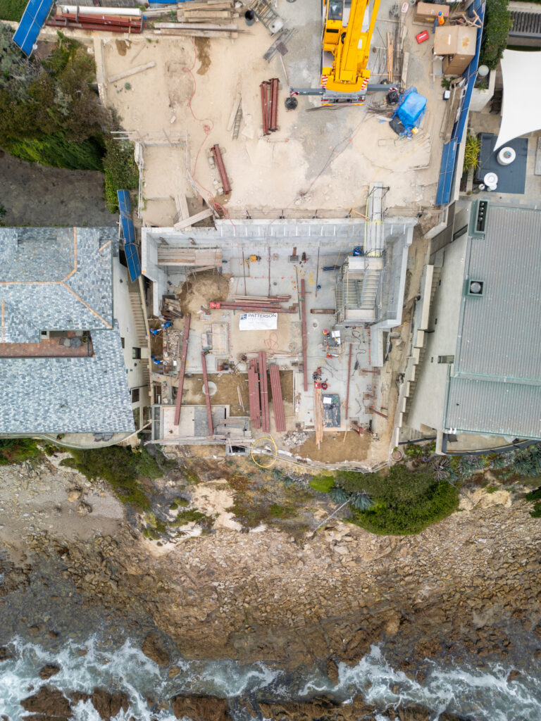
Drone photography helps solve that problem by providing a wider, more complete view of the property. From above, property owners, managers, contractors, developers, and stakeholders can better understand the layout, scale, and relationship between different areas of a site.

For large properties throughout Los Angeles County and Orange County, aerial photography provides a practical way to create clearer visual records, support communication, and document the property more effectively over time.
Why Large Properties Require Better Visual Documentation

The larger a property is, the harder it becomes to document clearly.

A small residential property may only need a few exterior photos to communicate the basic layout. Large properties are different. They often include several zones that need to be understood together.

This may include:

  • Main buildings
  • Parking lots
  • Driveways and access points
  • Common areas
  • Outdoor amenities
  • Landscaping
  • Storage or service areas
  • Surrounding roads and nearby structures

When these areas are photographed separately, the viewer may understand each detail but not the full picture. This can make it harder to explain the property to owners, investors, contractors, or off-site decision-makers.

Drone photography creates visual context. It shows how the property is organized and how each area connects to the next.

Aerial Photography Shows Scale More Clearly

Scale is one of the most important things drone photography provides.

Large properties are often difficult to explain through written descriptions. A commercial facility may cover several acres. An apartment community may include multiple buildings across a wide footprint. An industrial site may contain loading zones, service roads, and storage areas that are difficult to visualize from the ground.

Aerial photography allows stakeholders to see the entire property from a higher perspective. This makes it easier to understand:

  • How large the property is
  • How buildings are positioned
  • How vehicles and people move through the site
  • Where outdoor features are located
  • How different areas relate to one another

This type of visual documentation is especially helpful for people who cannot visit the property in person. Instead of relying on fragmented updates, they can review clear aerial images that show the full site in context.

Documenting Commercial Properties

Commercial properties often need visual documentation for many reasons. Owners may be planning improvements. Property managers may need updated records. Contractors may need to communicate in work areas. Leasing teams may need visuals that show the property clearly.

Drone photography can help document:

  • Retail centers
  • Office properties
  • Mixed-use developments
  • Parking areas
  • Exterior upgrades
  • Landscaping improvements
  • Tenant improvement areas
  • Access and circulation routes

For commercial properties, aerial photography is not only about appearance. It helps create a visual record that supports communication and long-term property understanding.

When a property has multiple tenants, buildings, or outdoor zones, drone photography can show the full environment in a way ground-level images cannot.

Documenting Apartment Complexes and Multi-Family Communities

Apartment complexes and multi-family communities often involve large footprints and many shared areas. A property may include residential buildings, leasing offices, pools, courtyards, walkways, parking lots, and landscaping.

Drone photography helps capture the full community layout in one connected view.

This can be useful for documenting:

  • Exterior renovation work
  • Roofing or building updates
  • Amenity areas
  • Parking lot improvements
  • Landscaping projects
  • Common outdoor spaces
  • Overall property condition over time

For property managers and ownership groups, aerial documentation can make updates easier to understand. Instead of sending multiple isolated photos, drone photography provides a clear view of the property as a whole.

This can be especially valuable when communicating with investors, board members, or regional managers who are not onsite every day.

Documenting Industrial Facilities

Industrial properties often have unique documentation needs because of their size and layout. These properties may include warehouses, loading docks, storage yards, equipment areas, paved lots, and access roads.

From the ground, it can be difficult to capture how these areas work together.

Drone photography provides a broader perspective that helps document the facility as a complete site. It can show building placement, exterior areas, circulation patterns, and large operational zones in a clear and organized way.

This can support:

  • Facility records
  • Property improvement updates
  • Asset documentation
  • Project communication
  • Long-term visual archives

Stone Harbor Media Group does not provide inspection services. However, aerial photography can still be valuable for documentation purposes. The images give stakeholders a clear visual record that can be reviewed alongside the appropriate professional evaluations when needed.

Large Residential Properties and Custom Projects

Large residential properties can also benefit from drone photography. Estates, custom homes, ranch-style properties, and residential developments often have outdoor features that are difficult to capture from the ground.

Aerial photography can document:

  • Overall property layout
  • Driveways and entry points
  • Pools and outdoor living areas
  • Guest houses or detached structures
  • Landscaping and hardscape features
  • Property improvements over time

For large residential projects, drone photography helps tell the full story of the property. It gives owners, builders, designers, and real estate professionals a better way to understand the space as a complete environment.

Why Drone Photography Improves Communication

Large property documentation often involves multiple people. Property owners, managers, contractors, designers, architects, investors, and other stakeholders may all need to understand what is happening across the site.

Drone photography creates a shared visual reference.

Instead of relying only on written notes or ground-level images, everyone can look at the same aerial visuals and understand the property more clearly. This can reduce confusion and help conversations stay focused.

Aerial documentation can help teams discuss:

  • Which areas were updated
  • Where future work may be planned
  • How different sections of the property connect
  • What the overall site looks like at a specific point in time
  • How the property has changed over time

For large properties, this clarity matters. The bigger the site, the easier it is for details to be misunderstood.

Creating Better Property Records Over Time

Properties change. Buildings are improved. Parking lots are updated. Landscaping matures. Outdoor areas are redesigned. New structures may be added.

Drone photography helps create a long-term visual record of those changes.

When aerial images are captured over time, property owners and managers can build a useful archive that shows how the property has evolved. This can support future planning, internal communication, marketing, and project history.

A strong visual archive can be especially helpful for commercial properties, apartment communities, industrial facilities, and large residential properties where changes happen across multiple areas.

Drone Photography and Professional Still Photography Work Together

Drone photography is most effective when paired with professional ground-level photography.

Aerial photos provide context and scale. Ground-level stills provide closer detail. Together, they create a more complete documentation package.

For example, aerial images can show the full apartment complex layout, while ground photography can capture individual amenity areas. Drone images can show the full commercial property, while ground-level stills can document entrances, signage, or exterior improvements.

This combination gives stakeholders both the big picture and the details they need.

Local Value for Los Angeles County and Orange County Properties

Large properties in Los Angeles County and Orange County often exist in dense, active environments. Commercial centers, apartment communities, industrial spaces, and large residential properties may be surrounded by nearby roads, neighboring structures, coastal conditions, or limited access areas.

Drone photography helps show these properties in context.

It allows stakeholders to see not only the property itself, but also how it sits within the surrounding environment. This is useful for documentation, planning, communication, and long-term visual records.

For local property owners and managers, working with a media partner that understands aerial photography, videography, and professional still photography can make the documentation process more useful and organized.

A More Complete Way to Document Large Properties

Documenting large properties requires more than a collection of isolated photos. It requires perspective, context, and consistency.

Drone photography helps provide that broader view. It allows commercial properties, apartment complexes, industrial facilities, and large residential projects to be documented more clearly and effectively.

For stakeholders who need to understand the full property, aerial visuals make communication easier. They show scale, layout, access, outdoor areas, and property changes in a way that ground-level images alone cannot fully capture.

Stone Harbor Media Group provides drone photography, drone videography, interior and exterior videography, and professional still photography for clients who need clear visual documentation of their properties. The goal is to help property owners, managers, contractors, and project teams communicate with greater accuracy and confidence.

keyboard_arrow_up